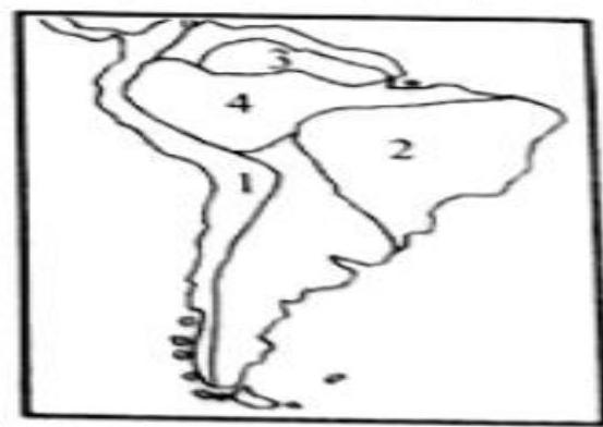
The physical regions marked as 1, 2, 3 and 4 on the given map are respectively
A
Andes, Brazilian Shield, Guyana Highlands and Amazon Basin
B
Andes, Guyana Highlands, Brazilian Shield and Amazon Basin
C
Amazon Basin, Guyana Highlands, Brazilian Shield and Andes
D
Guyana Highlands, Brazilian Shield, Andes and Amazon Basin
Correct Answer: Option A
Explanation
1. The question asks to identify the physical regions marked 1, 2, 3, and 4 on the given map (presumably of South America).
2. Without the actual map, precise identification is impossible. However, based on the typical geography of South America and the options provided:
- The Andes Mountains run along the western edge.
- The Guyana Highlands are in the northeast.
- The Brazilian Shield covers a large area of eastern and central South America.
- The Amazon Basin occupies the vast central-northern area.
3. Assuming the provided answer 'b' is correct, the labels on the map would correspond to: 1 - Andes, 2 - Guyana Highlands, 3 - Brazilian Shield, and 4 - Amazon Basin.
More Geography (World mapping) PYQs
- Consider the following countries : 1. United Kingdom 2. Denmark 3. New Zealand 4. Australia 5. Brazil How many of the above countries have more than four time zones?
- Consider the following pairs : 1. Country: Botswana, Resource-rich in: Diamond 2. Country: Chile, Resource-rich in: Lithium 3. Country: Indonesia, Resource-rich in: Nickel In how many of the above rows is the given information correctly matched?
- Consider the following pairs : 1. Region: Mallorca, Country: Italy 2. Region: Normandy, Country: Spain 3. Region: Sardinia, Country: France In how many of the above rows is the given information correctly matched?
- Consider the following countries : 1. Bolivia 2. Brazil 3. Colombia 4. Ecuador 5. Paraguay 6. Venezuela Andes mountains pass through how many of the above countries?
- Consider the following water bodies : 1. Lake Tanganyika 2. Lake Tonlé Sap 3. Patos Lagoon Through how many of them does the equator pass?
- Consider the following countries: 1. Finland 2. Germany 3. Norway 4. Russia How many of the above countries have a border with the North Sea?
Master UPSC Revision
Get 10,000+ topic-wise MCQs, spaced repetition, daily CSAT challenges, and detailed performance analytics.
Coming Soon to Play Store