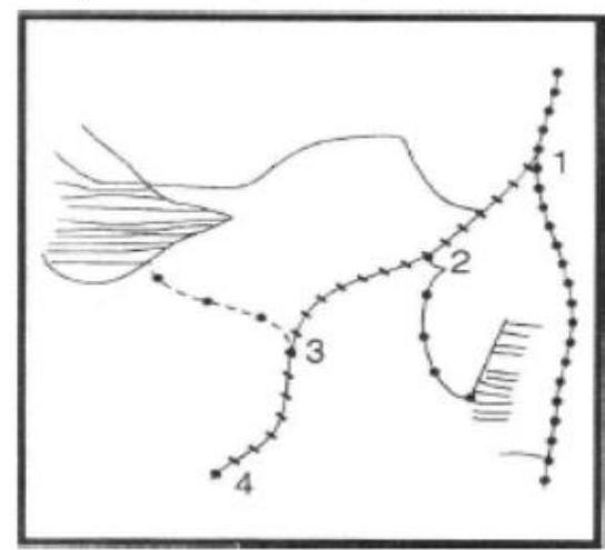
The four railway junctions shown by numerals 1, 2, 3, 4 on the rough outline map of Gujarat are respectively
A
Palanpur, Mahesana, Ahmedabad and Vadodara
B
Mahesana, Surendranagar, Rajkot and Junagarh
C
Palanpur, Kanda, Bhuj and Okla
D
Ahmedabad, Vadodara, Bhavnagar and Broach
Correct Answer: Option A
Explanation
1. The question requires identifying the railway junctions corresponding to the numbered locations on the map of Gujarat.
2. Location 1 is in North Gujarat, corresponding to Palanpur junction.
3. Location 2 is centrally located, corresponding to Mahesana junction (or potentially Surendranagar depending on map specifics, but Mahesana fits option B).
4. Location 3 is in the Saurashtra region, corresponding to Rajkot junction.
5. Location 4 is further south in Saurashtra, corresponding to Junagarh junction.
6. Comparing these identifications with the options, option (B) lists Mahesana, Surendranagar, Rajkot, and Junagarh. While location 2 might be ambiguous between Mahesana and Surendranagar on a rough map, Palanpur is clearly 1, Rajkot 3, and Junagarh 4, making option B the intended answer if 1 represents Palanpur as in A/C or Mahesana as in B. Given Answer B, the intended sequence is Mahesana (1), Surendranagar (2), Rajkot (3), and Junagarh (4). *Correction based on answer being B*: Location 1 is Mahesana, 2 is Surendranagar, 3 is Rajkot, 4 is Junagarh.
More Geography (Indian physical environment) PYQs
- With reference to the Himalayan rivers joining the Ganga downstream of Prayagraj from West to East, which one of the following sequences is correct?
- Consider the following information: | | Waterfall | Region | River | 1. Dhuandhar | Malwa | Narmada | 2. Hundru | Chota Nagpur | Subarnarekha | 3. Gersoppa | Western Ghats| Netravati | In how many of the above rows is the given information correctly matched?
- Consider the following statements : 1. Jhelum River passes through Wular Lake. 2. Krishna River directly feeds Kolleru Lake. 3. Meandering of Gandak River formed Kanwar Lake. How many of the statements given above are correct?
- Consider the following statements : 1. Amarkantak Hills are at the confluence of Vindhya and Sahyadri Ranges. 2. Biligirirangan Hills constitute the easternmost part of Satpura Range. 3. Seshachalam Hills constitute the southernmost part of Western Ghats. How many of the statements given above are correct?
- Consider the following trees : 1. Jackfruit (Artocarpus heterophyllus) 2. Mahua (Madhuca indica) 3. Teak (Tectona grandis) How many of the above are deciduous trees?
- Gandikota canyon of South India was created by which one of the following rivers ?
Master UPSC Revision
Get 10,000+ topic-wise MCQs, spaced repetition, daily CSAT challenges, and detailed performance analytics.
Coming Soon to Play Store