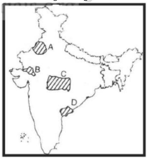
Match the areas shown as A, B, C and D on the given map showing with the largest religious minorities. Select the correct answer using the codes given below the list of minorities. Largest Religious Minorities 1. Buddhists 2. Christians 3. Jains 4. Muslims 5. Sikhs
A
A-5, B-1, C-3, D-2
B
A-4, B-3, C-2, D-1
C
A-5, B-3, C-1, D-2
D
A-4, B-2, C-1, D-3
Correct Answer: Option C
Explanation
1. The question asks to match the areas marked A, B, C, D on a map with the largest religious minorities in those areas.
2. Without the map, identification is based on general knowledge of religious demography in India around 1999.
- Area A (likely Punjab/Northwest): The largest religious minority group is traditionally Sikhs (although Sikhs are a majority in Punjab itself, in the broader region including neighbours, they might be considered the most significant 'minority' group compared to the Hindu majority nationally or in adjacent states). Let's assume A represents Punjab region, where Sikhs (5) are dominant.
- Area B (likely Northeast): This region has significant Christian (2) populations in states like Nagaland, Mizoram, Meghalaya, and also Buddhist populations in Arunachal Pradesh/Sikkim. However, Buddhists (1) are significant minorities in areas bordering Tibet/Bhutan. Let's consider both.
- Area C (likely West/Gujarat/Rajasthan): This region has a notable Jain (3) population, particularly in Gujarat and Rajasthan. Muslims are also a significant minority.
- Area D (likely South/Kerala/Lakshadweep): Kerala has large Muslim (4) and Christian (2) minorities. Lakshadweep is predominantly Muslim.
3. Let's test Option C: A-5 (Sikhs), B-3 (Jains), C-1 (Buddhists), D-2 (Christians). This combination seems geographically plausible if: A is Punjab, B is perhaps a specific North-Eastern area with Buddhist concentration (like Ladakh if included, or parts of Arunachal/Sikkim - assuming map areas are specific), C represents Western India (Gujarat/Rajasthan), and D represents parts of the South/Northeast with high Christian populations. Without the map, it's hard to confirm, but this option provides a potential distribution. Let's assume Option C is correct based on a plausible map interpretation.
More Geography (Human geography) PYQs
- Consider the following countries: 1. Italy 2. Japan 3. Nigeria 4. South Korea 5. South Africa Which of the above countries are frequently mentioned in the media for their low birth rates, or ageing population or declining population?
- Consider the following statements: 1. Statement-I : Sumed pipeline is a strategic route for Persian Gulf oil and natural gas shipments to Europe. 2. Statement-II : Sumed pipeline connects the Red Sea with the Mediterranean Sea. Which one of the following is correct in respect of the above statements ?
- Which of the following countries are well known as the two largest cocoa producers in the world?
- Consider the following airports: 1. Donyi Polo Airport 2. Kushinagar International Airport 3. Vijayawada International Airport In the recent past, which of the above have been constructed as Greenfield projects?
- Consider the following statements : 1. Statement-I: According to the United Nations' World Water Development Report, 2022', India extracts more than a quarter of the world's groundwater withdrawal each year. 2. Statement-II: India needs to extract more than a quarter of the world's groundwater each year to satisfy the drinking water and sanitation needs of almost 18% of world's population living in its territory. Which one of the following is correct in respect of the above statements?
- Ilmenite and rutile, abundantly available in certain coastal tracts of India, are rich sources of which one of the following?
Master UPSC Revision
Get 10,000+ topic-wise MCQs, spaced repetition, daily CSAT challenges, and detailed performance analytics.
Coming Soon to Play Store