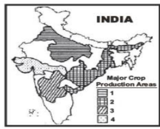
In the map given below four areas are differently shaded, three of which indicate cereal crops production areas and one indicates non-cereal crop production area. As per the index given, the non-cereal crop production area is
A
1
B
2
C
3
D
4
Correct Answer: Option D
Explanation
1. The map shows four differently shaded areas representing crop production regions in India.
2. Three areas indicate cereal crops production, and one indicates non-cereal crop production.
3. Area 1 covers Punjab, Haryana, and Western UP - a major wheat and rice (cereal) growing region (Green Revolution belt).
4. Area 2 covers parts of Gujarat and potentially western Maharashtra/MP - known for cotton (non-cereal cash crop) and groundnut (non-cereal oilseed), along with some cereals like bajra.
5. Area 3 covers the Gangetic plains of UP and Bihar - a major rice and wheat (cereal) growing region.
6. Area 4 covers the coastal regions of Andhra Pradesh and Tamil Nadu - major rice (cereal) growing areas.
7. Comparing the regions, Area 2 is most distinctly associated with major non-cereal cash crops like cotton and groundnut, although cereals are also grown there. Areas 1, 3, and 4 are primarily known for intensive cereal (rice and/or wheat) cultivation.
8. Therefore, Area 2 is the most likely representation of a non-cereal crop production area among the options.
More Geography (Human geography) PYQs
- Consider the following countries: 1. Italy 2. Japan 3. Nigeria 4. South Korea 5. South Africa Which of the above countries are frequently mentioned in the media for their low birth rates, or ageing population or declining population?
- Consider the following statements: 1. Statement-I : Sumed pipeline is a strategic route for Persian Gulf oil and natural gas shipments to Europe. 2. Statement-II : Sumed pipeline connects the Red Sea with the Mediterranean Sea. Which one of the following is correct in respect of the above statements ?
- Which of the following countries are well known as the two largest cocoa producers in the world?
- Consider the following airports: 1. Donyi Polo Airport 2. Kushinagar International Airport 3. Vijayawada International Airport In the recent past, which of the above have been constructed as Greenfield projects?
- Consider the following statements : 1. Statement-I: According to the United Nations' World Water Development Report, 2022', India extracts more than a quarter of the world's groundwater withdrawal each year. 2. Statement-II: India needs to extract more than a quarter of the world's groundwater each year to satisfy the drinking water and sanitation needs of almost 18% of world's population living in its territory. Which one of the following is correct in respect of the above statements?
- Ilmenite and rutile, abundantly available in certain coastal tracts of India, are rich sources of which one of the following?
Master UPSC Revision
Get 10,000+ topic-wise MCQs, spaced repetition, daily CSAT challenges, and detailed performance analytics.
Coming Soon to Play Store