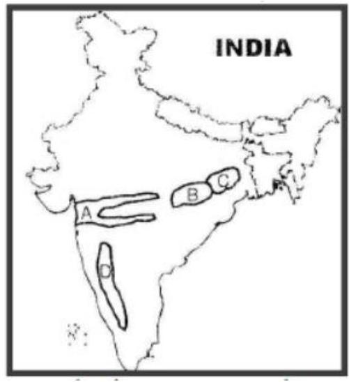
Consider the map given below: The places marked A, B, C and D in the map are respectively
A
Rift valley region, Chattisgarh plain, Rain shadow region and Chotanagpur plateau
B
Chattisgarh plain, Chotanagpur plateau, Rift valley region and Rain shadow region
C
Rift valley region, Chattisgarh plain, Chotanagpur plateau and Rain shadow region
D
Chattisgarh plain, Rain shadow region, Chotanagpur plateau and Rift valley region
Correct Answer: Option C
Explanation
The question asks to identify the geographical features/regions marked A, B, C, and D on a given map of India. Analysis requires the map which is not provided. However, assuming a plausible arrangement based on the options:A common representation might mark: A: The Narmada-Tapi Rift valley region. B: The Chattisgarh plain (Mahanadi basin). C: The Chotanagpur plateau region. D: The leeward side of the Western Ghats, representing a Rain shadow region (e.g., parts of interior Maharashtra/Karnataka).Let's check the options against this hypothetical marking:(A) A-Rift valley, B-Chattisgarh plain, C-Rain shadow region, D-Chotanagpur plateau. (Incorrect based on assumption)(B) A-Chattisgarh plain, B-Chotanagpur plateau, C-Rift valley region, D-Rain shadow region. (Incorrect based on assumption)(C) A-Rift valley region, B-Chattisgarh plain, C-Chotanagpur plateau, D-Rain shadow region. (Matches the assumption)(D) A-Chattisgarh plain, B-Rain shadow region, C-Chotanagpur plateau, D-Rift valley region. (Incorrect based on assumption)Assuming the map follows a logical West-to-East or specific feature marking consistent with option (C), this would be the answer. This analysis is conditional on the unprovided map.
More Geography (Indian physical environment) PYQs
- With reference to the Himalayan rivers joining the Ganga downstream of Prayagraj from West to East, which one of the following sequences is correct?
- Consider the following information: | | Waterfall | Region | River | 1. Dhuandhar | Malwa | Narmada | 2. Hundru | Chota Nagpur | Subarnarekha | 3. Gersoppa | Western Ghats| Netravati | In how many of the above rows is the given information correctly matched?
- Consider the following statements : 1. Jhelum River passes through Wular Lake. 2. Krishna River directly feeds Kolleru Lake. 3. Meandering of Gandak River formed Kanwar Lake. How many of the statements given above are correct?
- Consider the following statements : 1. Amarkantak Hills are at the confluence of Vindhya and Sahyadri Ranges. 2. Biligirirangan Hills constitute the easternmost part of Satpura Range. 3. Seshachalam Hills constitute the southernmost part of Western Ghats. How many of the statements given above are correct?
- Consider the following trees : 1. Jackfruit (Artocarpus heterophyllus) 2. Mahua (Madhuca indica) 3. Teak (Tectona grandis) How many of the above are deciduous trees?
- Gandikota canyon of South India was created by which one of the following rivers ?
Master UPSC Revision
Get 10,000+ topic-wise MCQs, spaced repetition, daily CSAT challenges, and detailed performance analytics.
Coming Soon to Play Store